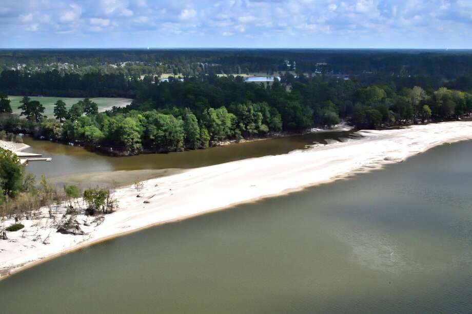
Harvey washed sand downstream from mines in Porter in Montgomery County. After the storm, new dunes up to ten feet high covered 30 acres of Kingwood’s East End Park on the East fork of the San Jacinto River and obliterated trails like this one.
lessHarvey washed sand downstream from mines in Porter in Montgomery County. After the storm, new dunes up to ten feet high covered 30 acres of Kingwood’s East End Park on the East fork of the San Jacinto River
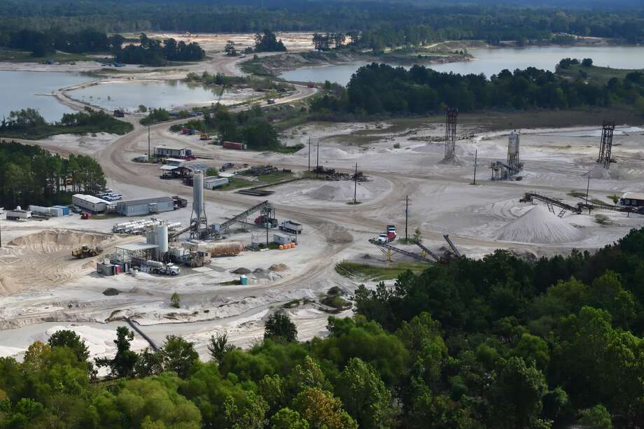
... moreThe West Fork of the San Jacinto winds its way through approximately 3,400 acres of sand mines immediately west of Kingwood. In the foreground, you see sand deposited by Harvey when floodwaters breached the dikes surrounding the mines.
lessThe West Fork of the San Jacinto winds its way through approximately 3,400 acres of sand mines immediately west of Kingwood. In the foreground, you see sand deposited by Harvey when floodwaters breached the
... moreHarvey’s floodwaters breached dikes surrounding the sand mines on the west fork of the San Jacinto. This let sand escape. It was carried downstream and deposited in Humble, Forest Cove, Kingwood and Atascocita.
lessHarvey’s floodwaters breached dikes surrounding the sand mines on the west fork of the San Jacinto. This let sand escape. It was carried downstream and deposited in Humble, Forest Cove, Kingwood and
... moreNotice sand in the tree tops (lower left) near Forest Cove (upper left) just east of I-69 downstream from the sand mines on the west fork of the San Jacinto.
Notice sand in the tree tops (lower left) near Forest Cove (upper left) just east of I-69 downstream from the sand mines on the west fork of the San Jacinto.
The estimated height of the dune is 12 feet to 15 feet. Water from the drainage ditch (foreground) must now take a 90-degree left turn to get to the river, slowing its velocity and backing up the ditch in a flood.
lessThe estimated height of the dune is 12 feet to 15 feet. Water from the drainage ditch (foreground) must now take a 90-degree left turn to get to the river, slowing its velocity and backing up the ditch in a
... moreThe boardwalk at River Grove Park (center left) has long been a popular place for fishing, bird watching and family photos. The once-gorgeous lagoon is now filled with sand. Beyond it is the new sandbar shown in the previous two photos. Upper right is the river-blocking dune shown in the next photo.
lessThe boardwalk at River Grove Park (center left) has long been a popular place for fishing, bird watching and family photos. The once-gorgeous lagoon is now filled with sand. Beyond it is the new sandbar shown
... moreJust downstream from River Grove Park in Kingwood, a new sandbar has formed on the west fork of the San Jacinto. Boats that draw 18 inches of water can no longer navigate upstream (foreground) past this sandbar.
lessJust downstream from River Grove Park in Kingwood, a new sandbar has formed on the west fork of the San Jacinto. Boats that draw 18 inches of water can no longer navigate upstream (foreground) past this
... moreWhere the west fork of the San Jacinto crosses under the West Lake Houston Parkway bridge, you can now see sand in the treetops (foreground). This turned water north toward Kings Harbor (background). It was among the worst flooded areas in Kingwood.
lessWhere the west fork of the San Jacinto crosses under the West Lake Houston Parkway bridge, you can now see sand in the treetops (foreground). This turned water north toward Kings Harbor (background). It was
... moreLooking north up Caney Creek where it joins the east fork of the San Jacinto at East End Park in Kingwood (foreground). Note the newly deposited sandbars that reduce the cross section of the creek.
Looking north up Caney Creek where it joins the east fork of the San Jacinto at East End Park in Kingwood (foreground). Note the newly deposited sandbars that reduce the cross section of the creek.
Sand mines along Caney Creek upstream from Kingwood in Montgomery County exposed more than 600 acres of sand surface to Harvey’s floodwaters.
Sand mines along Caney Creek upstream from Kingwood in Montgomery County exposed more than 600 acres of sand surface to Harvey’s floodwaters.
Just downstream from sand mines in Porter in Montgomery county, Caney Creek (foreground) joins the east fork of the San Jacinto (upper left and background). Note how sand from the mines is now reaching the treetops.
lessJust downstream from sand mines in Porter in Montgomery county, Caney Creek (foreground) joins the east fork of the San Jacinto (upper left and background). Note how sand from the mines is now reaching the
... moreGround-level shot of the dunes in the previous photo. Taken from Kingwood’s East End Park where Caney Creek joins the east fork of the San Jacinto. These dunes reach an estimated 12 to 15 feet.
Ground-level shot of the dunes in the previous photo. Taken from Kingwood’s East End Park where Caney Creek joins the east fork of the San Jacinto. These dunes reach an estimated 12 to 15 feet.
A giant sand dune has formed where the east and west forks of the San Jacinto (left and right foreground) join, inhibiting the flow of the river. Engineers say that sediment is not being carried out into Lake Houston (background) as expected. Areas beyond these dunes experienced far less flood damage from Harvey than the areas behind them.
lessA giant sand dune has formed where the east and west forks of the San Jacinto (left and right foreground) join, inhibiting the flow of the river. Engineers say that sediment is not being carried out into Lake
... moreDuring Harvey, an estimated 16,000 homes and 3,300 businesses in the Lake Houston area flooded. According to Dave Martin, Houston City Council member for this area, damages will run into the billions, and the tax base could be reduced 20 percent to 30 percent in 2018.
In my subdivision alone, 45 percent of the homes flooded – all but two or three had never flooded before, even in 1994 and during Tropical Storm Allison.
What was different this time? Was it simply the volume of rain, or was something else also at work here?
After the flood subsided, I observed new sand dunes along the shores of the San Jacinto River – some higher than 15 feet! Where did all this new sand come from? Was there a connection between it and the flooding?
To find answers, I rented a helicopter and surveyed the east and west forks of the San Jacinto. My search also led to State senate and house hearings. I had meetings with public officials at the local, county, state and federal levels. I also interviewed flood experts from Galveston and Harris counties. Here is what I found: Humans exacerbated flooding along the San Jacinto in ways that they didn't in other parts of Houston.
One small part of sand mining operations on the west fork of the San Jacinto in Montgomery County. The mines stretch approximately four miles north to south upstream from Humble and Kingwood.
Mitigating the risk of future flooding will almost surely, in my opinion, require eliminating sand mining operations on both the east and west forks of the San Jacinto. Adjacent to Kingwood alone, these mines have denuded 4,000 acres of riverfront – almost 30 percent of the size of Kingwood.
While virtually invisible from the ground, from the air their devastation is shocking. Satellite and aerial photos reveal that Harvey's floodwaters breached the dikes surrounding the mines. The swirling floodwaters scooped up an incalculable amount of sand and deposited it downstream, blocking and backing up drainage ditches, streams and the river itself. Many of my photos show sand in treetops. If the sand is piled that high onshore, imagine how much it reduced the carrying capacity of the river!
RELATED: Twelve steps Houston can take to address our flooding problem
Certainly, the extreme nature of Harvey made large-scale damage inevitable. But were it not for the actions of humans, many homes and businesses that never flooded before might have been saved.
Collectively, we:
1) Allowed mining operations to clog the San Jacinto river with sand
2) Failed to follow engineer's recommendations to dredge the river
3) Designated multiple agencies with conflicting mandates to govern the river
4) Created a San Jacinto River Authority (SJRA) that failed to protect downstream interests
5) Created a bottleneck in the river with dams that have different release rates
A drainage ditch (center left) that empties the entire western part of Kingwood at River Grove Park on the west fork of the San Jacinto has been virtually closed off by a new sandbar. An estimated 500+ homes above this point flooded. The boat dock (also center left) is now unusable.
We need to move from identifying culpability to fixing problems. By acting now to get rid of the bottleneck at the river and the politics that surround it, we can improve public safety and mitigate damage from future storms.
Translator
To read this article in one of Houston's most-spoken languages, click on the button below.
Here, in my opinion, is what we should do to address each of these issues. Many experts agree.
1) Reduce the rate of sedimentation: Buy land occupied by sand mines and turn it into parks. Stabilize soil with plants, trees and grass to reduce erosion.
2) Dredge the San Jacinto: We must improve the velocity and carrying capacity of the river. A 2001 Brown & Root study recommended dredging to mitigate flooding. So far, not one yard of sand has been removed. Sand deposited during each new flood reduces river capacity. The last sedimentation survey of the west fork in 2011 showed an average depth of less than five feet. It's now inches deep in many places. Parts have become unnavigable with boats that draw as little as 18 inches.
3) Debottleneck the politics of flood management: We need to create a unified command structure along the entire river with the primary mission of reducing flooding. Currently, Harris County Flood Control District and the SJRA govern the river. However, the SJRA's enabling legislation gave it responsibility for flood control and environmental preservation on one hand, and water conservation and economic development on the other.
These mandates can conflict with each other. In the agency's 81-year existence, it has allowed sand mines to decimate the banks of the river and failed to build even one flood-control dam. The SJRA has certainly helped economic development in Montgomery County. However, Montgomery County sand mines along the river have contributed to flooding in Harris County. We need to establish flood management as the top priority for all agencies governing the San Jacinto.
RELATED: To fight flooding in Houston, we have to think big
4) Appoint an SJRA board that represents the upper Lake Houston area: People living there suffered most of the consequences of SJRA's actions during Harvey, but have no representation on their board. That board now has two vacancies; we should urge the governor to appoint representatives from this area.
5) Modify the Lake Houston Dam: Prereleasing water in anticipation of a major storm can reduce flood damage because lowering a lake's level reduces the height of the flood. However, Lake Houston cannot shed water as quickly as Lake Conroe; Lake Houston has a fixed-height spillway and Lake Conroe has tainter gates. The SJRA cited this as their reason for not prereleasing water from Lake Conroe; they said they feared flooding the Lake Houston area. We need to replace Lake Houston's dam with one that has tainter gates. That will let both lakes prerelease water at the same rate, eliminating the Lake Houston bottleneck and reducing future flood damage.
Generic solutions designed for other parts of Houston could help in the upper Lake Houston area, but they won't address the root causes of flooding here. These recommendations will. We need action now. Four and a half months have passed since Harvey, and not one thing has changed on the ground that would reduce the risk from another major rain event. The next hurricane season is just four and a half months away.
Bob Rehak, a retired businessman living in Kingwood, has become active in flood recovery efforts.
Bookmark Gray Matters. Many experts agree.
0 Response to "Harvey showed why we have to stop mining sand on the San Jacinto River - Houston Chronicle"
Post a Comment